


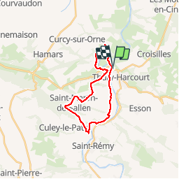
thury-st martin de sallen

albers
User

Length
19.9 km

Max alt
218 m

Uphill gradient
548 m
Km-Effort
27 km

Min alt
23 m

Downhill gradient
548 m
Boucle
Yes
Creation date :
2014-12-10 00:00:00.0
Updated on :
2014-12-10 00:00:00.0
4h31
Difficulty : Medium

FREE GPS app for hiking
 SityTrail
IGN / Geographical institutes
SityTrail Plus
The world is yours!
About
Trail Walking of 19.9 km to be discovered at Normandy, Calvados, Le Hom. This trail is proposed by albers.
Description
belle rando de beaux paysages vu sur la vallée de l''orne.
un peu de dénivelé mais c''est la suisse normande!!!!
Positioning
Country:
France
Region :
Normandy
Department/Province :
Calvados
Municipality :
Le Hom
Location:
Thury-Harcourt
Start:(Dec)
Start:(UTM)
684185 ; 5429347 (30U) N.
Comments
beaucoup de goudron